The Southern Loop
THE SOUTHERN LOOP

I believe that the Earth is a sphere and that the Moon landings did occur, and while I am unsure of the cause, I am convinced that our climate is changing.
The Summers' of my childhood, many decades ago, were always hot and dry and ran from mid December to late February. Nowadays, Summer seems to run from mid-November to late March and has become hotter and wetter.
This year's Grand Tour started on 01 March, which coincides with the start of our Autumn, a period historically of cooling temperatures and reducing rainfall, making for pleasant riding conditions.
Instead, this past month we have "enjoyed" multiple consecutive days where the temperature has been above 35*C / 95*F, closely followed by consecutive days of constant rain.
It would be fair to say that I was becoming desperate as my last "get-away" ride was back in November, and April is blocked out with family commitments and public & school holidays.
So, my window of opportunity was this past week, a "now or never" situation, but the weather forecast was not good.
Wednesday & Thursday were forecast to be "hot & dry" as in 35*C/95*F with only a 5% chance of rain, while Friday was forecast "cold & wet", as in 20*C/58*F and 90% chance of rain.
Not ideal ATGATT riding weather, but as I said, I was desperate, so at "sparrow fart" on Wednesday, I loaded up my bike and began the 3-day South Coast Loop ride.
My first stop was in Mittagong, a small town in the Southern Highlands, about 150 km from my home. However, getting there involved riding through the morning peak-hour traffic on the M2/M7.
Fortunately, the traffic was moving smoothly, and I made good time to the Gumnut Patisserie (established in 2008) for that all-important first coffee and a delicious high-sugar pastry. Oh, and a bonus photo as well.

From Mittagong, it was a short ride to Moss Vale, and another bonus photo of Pollie's Pies & Pastries (est 2009), although the building looks a lot older than that.


However, this year is pretty special. Due to unusually high rainfall, it looks like an actual lake, with the water nearly reaching the edge of the Federal Highway.

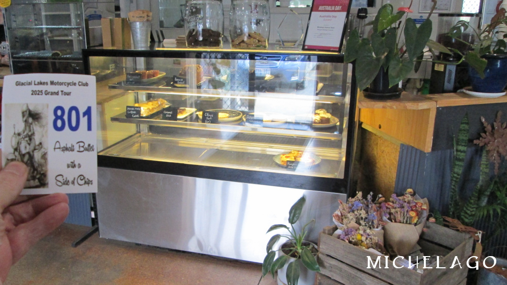
From Bungendore, I skirted Queanbeyan and headed down the Monaro Hwy to the small farming village of Michelago. There is an Ampol petrol station, a Public School and a General Store, which serves good coffee and has a nice selection of cakes. The perfect afternoon stop for a "leg stretch".

Brown Mountain has an elevation of 1,243 m / 4,078 ft and is the highest mountain in the Monaro area of the Great Dividing Range. It is a native forest area, with steep hillsides heavily timbered with large trees combined with thick undergrowth.
The ride up the mountain from Bemboka to Steeple Flat, approx 30 km, involves multiple switch-back hairpin turns and is a popular biker's road.
The run down the mountain, while not as much fun as the ascent, is challenging and can be enjoyable. That is, provided the weather is in your favour, as in blue skies / no mist.
Unfortunately for me, the weather had changed during the short period since leaving Cooma and my run down Brown Mountain, with its multiple hairpin turns, was done in misty rain and fog, with visibility down to about 10 m / 10 yd.
And to add a little extra spice to the ride down the mountain, a small kangaroo decided that we should "share" the same section of road, at the same time.
Through a combination of outstanding riding skill and just plain good luck, there was no collision and I did not end up riding over a cliff. Mind you, I may need to invest in new underwear.
By the time I reached the township of Candelo at the base of the mountain, my heart rate had returned to normal and I bagged another bonus photo, this time of the Family Hotel (est 1865).

From Candelo, I headed to Merimbula on the coast for fuel and a bonus photo of the Tidal Wine Bar, before turning north along the Prince's Hwy to Cobargo and a bonus photo of the Cobargo Hotel.
The original hotel was built around 1865, but was replaced with the current brick building sometime in the 1950s.

It seems that during World War II, Moruya, like many coastal towns in Australia, was concerned about the possibility of air raids from Japanese forces, and to prepare for such events, the local council decided to build a temporary shelter for the residents on the site of an old hotel's stables.
Fortunately, it was never used for its "primary" purpose.


The first order of business over Friday's breakfast was to review the latest B.O.M weather forecast.
Unfortunately, it had deteriorated further, and was now almost constant rain, progressively getting heavier during the day, so an impromptu re-scheduling of the day's ride was reluctantly done.
Several bonus photo opportunities were abandoned (win some / lose some) and a "quick zip up the highway" plan was developed.
When I finally got underway, the light misty type of rain was just heavy enough to obscure my visor and be annoying.
When I reached the township of Berry, about 80 km further north, the rain had turned into real rain, heavy enough for me to pull over to the side of the road and put on my plastic wet weather jacket.
At Gerringong, I took the off-ramp and quickly re-fuelled and bagged a bonus photo of the near-by Jack's Grill sign on the Cronin's Hotel (est 1890)

My Bridgestone T32 tyres have a good "wet road" feel and are good at pumping water away, however, aqua-planing was a real concern, so my speed dropped considerably.
About now, as I was struggling for traction and visibility, and with a heighten sense of self-preservation, it crossed my mind that I was no longer having "fun", and that maybe a Mazda MX-5 ( Miata ) might be a better solution for the next year's Grand Tour.
I know, it's not technically a "motorcycle", but what is an extra wheel or two among friends ?
The run-up Picton Road from the coastal lowland area to the highland plateau is about 30 km and when I reached the Hume Hwy on-ramp, the rain had reverted back into the "annoying" light misty rain.
From Picton, it was a largely uneventful ride to the M7, through the extended roadworks to the M2, and onto Ryde Rd and the final 20 km to my home for a hot shower and a cold beer.
All up, I spent 15.5 hours in the saddle, travelled around 1,136 km and consumed 55 litres of fuel, which produced 126 kg / 278 lbs of climate changing CO2.
I am reminded of Galatians 6:7 " Do not be deceived: A person reaps what they sow "
As I mentioned at the beginning of this report, I doubt that I will get the chance for another ride in April, so my planning will now focus on an early May ride instead.
Fingers crossed that the Rain Gods take pity on me and grant me a few consecutive days of sunshine.


Comments
Post a Comment